
Introduction
At the time of this blog, we just had an historic US presidential election. We had a bit of fun with our kids on the election, and thought we’d pass along the activity idea. This interactive project allows them to explore how the Electoral College works, why states are assigned specific electoral votes, and how each state contributes to the final results. This activity also gives kids the opportunity to color, add, and analyze—providing them a fun, educational perspective on a major national event. This is a fun way to introduce geography, civics, and basic math, all while making the learning experience memorable.
Read on for a guide to making your own Electoral College map and introducing young learners to key concepts of American democracy!
Step-by-Step Guide to Drawing a Political Map for Kids
- Print a Map of the United States
Start by printing a blank outline of the United States with all 50 states clearly labeled. This will be the foundation for the political map. - Print a List of the Number of Electorates for Each State
The next step is to print a list showing the number of electoral votes each state holds. This is important because it’s a key part of understanding the U.S. Electoral College system. Let kids know that the number of electoral votes varies by state, depending on population size. Have the kids write the number of electoral votes each state has on the state (or close by). - Introduce the Electoral College
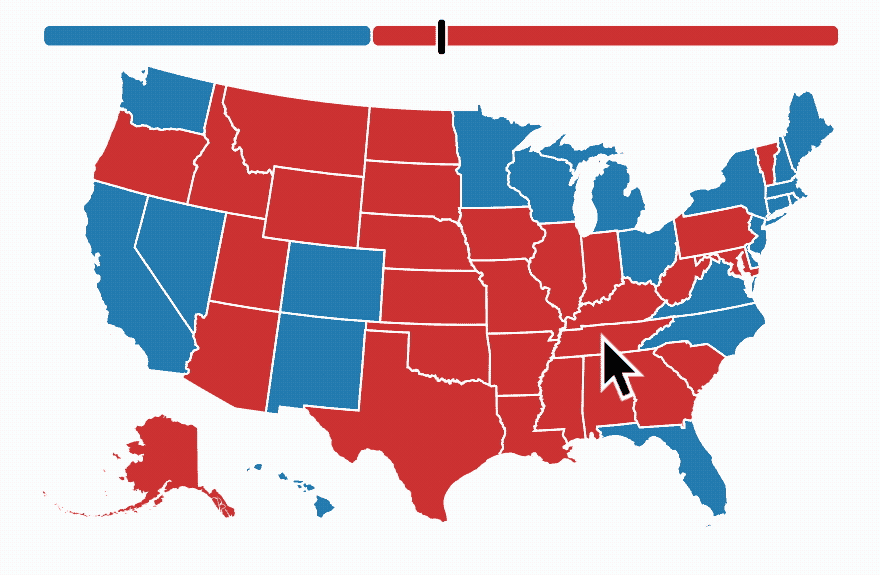
Explain that in U.S. presidential elections, citizens in each state vote, but instead of just counting the individual votes, each state contributes a certain number of electoral votes based on its population. This system means that states with larger populations have more influence in the election. Each state’s electoral votes are “won” by a candidate who wins the majority of votes in that state. - Coloring the Map: Blue and Red States
Now, let kids color in the states! You can use a recent election map or create your own. Ask them to color states blue if they were won by the Democratic candidate or red for the Republican candidate. This coloring exercise is a simple way to help kids start recognizing states and understanding their influence in the Electoral College. You can make this fun by pretending to be a political pundit announcing the electoral college results as they come in. - Keeping Track of the Math
As kids color in the states, help them add up the total electoral votes on each side. Explain that the goal is to reach a majority—270 out of 538 electoral votes—to win the election. This part of the activity allows kids to practice addition and work toward a goal, providing a satisfying finish to the exercise. We used our whiteboard to do this together.
Why This Activity Works Well Across Different Disciplines
This map-drawing activity is versatile, educational, and can be adapted for a range of subjects:
1. Geography
- Skill: Identifying U.S. states and understanding their locations.
- Benefits: Kids improve their map-reading skills and become familiar with the layout of the country. When locating the states, we gave hints through cardinal directions (looking for Nevada? Go west!)
- Classroom Application: This is a great activity for elementary geography classes as it helps students visualize the country’s states and see how they contribute to the national political landscape.
2. Civics / Social Studies
- Skill: Learning about the Electoral College and the U.S. presidential election process.
- Benefits: Kids learn about a fundamental part of U.S. democracy in a way that is simple, visual, and interactive.
- Classroom Application: Perfect for a civics or social studies class, this activity provides context for discussions on how voting and elections work.
3. Math
- Skill: Basic arithmetic and addition skills.
- Benefits: Kids keep track of electoral votes for each candidate, helping reinforce addition and understanding of greater-than/less-than as they approach 270.
- Classroom Application: A math lesson can incorporate this activity by focusing on the addition of electoral votes and practicing “winning” combinations for each candidate.
4. History
- Skill: Understanding the historical significance of voting patterns.
- Benefits: While coloring in states, kids can see which states have been historically red or blue and why.
- Classroom Application: In a history class, teachers can expand on how voting patterns have evolved and the historical contexts behind these trends.
5. Art
- Skill: Coloring, spatial awareness, and attention to detail.
- Benefits: Kids can express themselves creatively while working within the boundaries of a state map.
- Classroom Application: Teachers can encourage kids to be precise with their coloring and even get creative with symbols or drawings that represent each state.
Conclusion
This political map activity is a fantastic way for kids to learn about U.S. geography, history, math, and civics all at once. It engages them in the basics of the U.S. election process while allowing them to interact with the map in a colorful, memorable way. Whether you’re a teacher or a parent looking for a fun, educational activity, this is a great project to build both curiosity and foundational knowledge about how elections work. Plus, the pride kids will feel in finishing their very own electoral map is hard to beat!